Difference between revisions of "Who uses OpenJUMP"
Jump to navigation
Jump to search
| (2 intermediate revisions by the same user not shown) | |||
| Line 15: | Line 15: | ||
* State Survey and Geospatial Basic Information (LGN, Lower Saxony, Germany) | * State Survey and Geospatial Basic Information (LGN, Lower Saxony, Germany) | ||
* Health Department of the Indonesian Province of Nusa Tengarra Timur (see [http://healthpslp.cdu.edu.au/index.html here]) | * Health Department of the Indonesian Province of Nusa Tengarra Timur (see [http://healthpslp.cdu.edu.au/index.html here]) | ||
| − | |||
* ... | * ... | ||
== Users in Teaching and Research == | == Users in Teaching and Research == | ||
| − | * | + | * HafenCity University Hamburg (Germany) |
* University of Zurich (Switzerland) | * University of Zurich (Switzerland) | ||
* University of Calgary (Canada) | * University of Calgary (Canada) | ||
* ITC Enschede (The Netherlands) | * ITC Enschede (The Netherlands) | ||
| − | * Leibniz-University Hanover (Germany) | + | * [http://www.umwelt.uni-hannover.de/manuela.html Leibniz-University Hanover] (Germany) |
* Laboratoir Cogit, IGN France (France) | * Laboratoir Cogit, IGN France (France) | ||
* Research Division of Ordnance Survey GB (UK) | * Research Division of Ordnance Survey GB (UK) | ||
| Line 33: | Line 32: | ||
* University of Edinburgh (UK) | * University of Edinburgh (UK) | ||
* University of Osnabrueck (Germany) | * University of Osnabrueck (Germany) | ||
| + | * [http://gis.vsb.cz/ruzicka/Projekty/jump/index.php Technical University of Ostrava] (Czech Republic) | ||
* ... | * ... | ||
| Line 46: | Line 46: | ||
== Open Street Map Project == | == Open Street Map Project == | ||
| − | * | + | * OpenJUMPs Road Matcher Plugin has been used for a road data conflation project by the Canadian [http://wiki.openstreetmap.org/wiki/Geobase_NRN_-_OSM_Map_Feature OpenStreetMap Group] to update their road database - especially with roads in remote areas. |
== User World Map == | == User World Map == | ||
Latest revision as of 22:32, 29 August 2010

Note: please add yourself if you like to
You can find institutions and individuals that use or have used OpenJUMP in the past below. You may have as well a look on our Testimonials page
Users in Public Administration
- BC Ministry of Sustainable Resource Management (Canada)
- Ontario - Ministry of Natural Resources (Canada)
- Information Centre of the Ministry of Agriculture and Forestry (Finland)
- City of Erfurt - Civil Engineering Department (Germany)
- Canton St. Gallen - Surveying Department (Switerland)
- Institute Geographique National (France)
- State Survey and Geospatial Basic Information (LGN, Lower Saxony, Germany)
- Health Department of the Indonesian Province of Nusa Tengarra Timur (see here)
- ...
Users in Teaching and Research
- HafenCity University Hamburg (Germany)
- University of Zurich (Switzerland)
- University of Calgary (Canada)
- ITC Enschede (The Netherlands)
- Leibniz-University Hanover (Germany)
- Laboratoir Cogit, IGN France (France)
- Research Division of Ordnance Survey GB (UK)
- Instituto Ecos (Brazil)
- University of Pardubice (Czech Republic)
- Centro Fed. de Educacao Tecnologica de Bambui (Brazil)
- University of Hohenheim (Germany)
- University of Edinburgh (UK)
- University of Osnabrueck (Germany)
- Technical University of Ostrava (Czech Republic)
- ...
Users in Companies
- Refractions Research (Rapid Prototyping, Data Viewer)
- Axes Systems (Generalization Prototype development)
- Boston GIS (OpenJUMP as PostGIS client)
- BWS GmBH (DE, Customized tools for Environmental Analysis)
- ...
There are obviously a couple of since they sponsored customized developments... but we don't know them.
Open Street Map Project
- OpenJUMPs Road Matcher Plugin has been used for a road data conflation project by the Canadian OpenStreetMap Group to update their road database - especially with roads in remote areas.
User World Map
yes, we also have a User World Map:
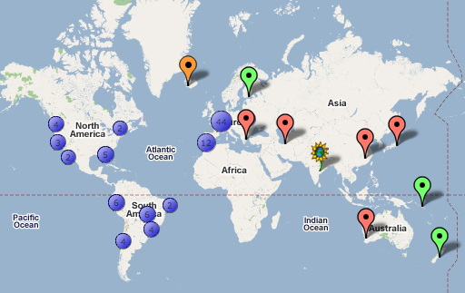
To add yourself to this map click...
- here: ZeeMAPS
- click on “login” (not on “sign-in”) and,
- use the password: ojmember