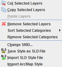
Layer
Jump to navigation
Jump to search
Back to List of Functions
- Add MrSID Layer - (this function is now part of the normal file open dialog)
- Opens aerial or satellite photos in MrSid format (.SID extentson).
- This function is deactivated for default. To activate this function user must install the MrSid extension in OpenJUMP.
- TIP: to install MrSID extension: (note: instructions for NightlyBuild below)
- (1) download mrsidgeodecode.exe and mrsidgeoinfo.exe from LizardTech website,
- (2) on Windows platforms create a ECT folder in the 'program' folder (e.g. 'C:\Program Files\etc\') and put the 2 files in it.
- (3)Now, rename the files: mrsidgeodecode_win.exe to mrsiddecode.exe and mrsidgeoinfo_Win.exe to mrsidinfo.exe.
- (4) Start OpenJUMP and look if you can load the files
- (6) Create also a TEMP folder inside OpenJUMP install folder and give it read/write permissions. This is where the Openjump stores temp info for the MrSID images being read. This trick probabily works only for MS Windows based Operative Systems.
- If you encounter problems with the new Lizard extensions, download the old mrsidinfo.exe file here
- for users of nighlty build (since May 2008): place the files: mrsidgeodecode.exe and mrsidgeoinfo.exe in the /etc/ folder of OpenJUMP. Create also the folder called "TMP" in the OJ "ETC" folder. that's it. Check now if the option to load "MrSID" files is offered in the file load dialog.
- Cut Selected Layers - Cut selected layers off from the Layer List and Layer View. This function works both raster and vector layers
- Copy selected layers - With this function selected layers can be copied from a category in the Layer List
- Paste layers - Copied layers can be pasted in another category. The new layer take the same name of the original one with a consecutive number (Layer(2), Layer(3)...). New layers have to be saved after copied in order not to loose datas
- Sort Selected Categories - Sort layers in selected categories :
- By Features
- By Most Number of Features - Layers with more features on the top.
- By Least Number of Features - Layers with less features on the top.
- By Name
- Ascending - Layer name starting with A above layer name starting with B.
- Descending - Layer name starting with A below layer name starting with B.
- Restore - Order is restored to its state at the last save operation state.
- Save - Save the order to be able to restore to this state.
- By Features
- Remove selected layers - Selected layers can be removed from Layer List
- Remove selected categories - Selected categories can be removed from Layer List.
- Change SRID... - “Spatial Reference Identifier” (SRID) defines the property of the used projection or coordinate system. With “Change SRID...” function it is possible to change the SRID of a selected datastore layer. For better explanation about “Spatial Reference Identifier” see Morten Nielsen's definition
- Save Style as SLD File - Transform the style of a selected leyer in a SLD (Style Layer Descriptor). SLD is basically a schema in xml format which describes the apparence of the layer. SLD can be read by more and more GIS. You can read more about the format here.
- Import SLD Style File - This function allows to import a SLD style file to a layer. Other GIS software like uDig and Kosmo can export to SLD format
- Import ArcMap Style - Import Styles from ArcMap
<--- back to List of Functions
